Salmon River Restoration Council
- Overview
- Whitewater
- Wilderness
- Camping
- Fishing & Hunting
- Snowsports
- Cycling
Overview
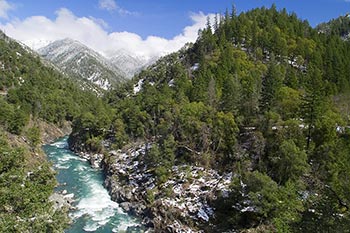 Salmon River after a spring snowPhoto: Scott Harding
The Salmon River watershed offers a multitude of outdoor recreation experiences in a spectacular and remote setting.
Over ninety-eight percent of the watershed is public land administered by the Klamath National Forest and includes substantial portions of the Marble Mountain, Russian, and Trinity Alps Wilderness Areas plus wonderful stretches of designated Wild & Scenic rivers.
Activities
Depending upon the seasons and weather, the Salmon River offers exceptional whitewater kayaking and rafting, both road and mountain biking rides, hundreds of miles of hiking and packing trails in three wilderness areas, front country and back country camping, fishing and hunting, plus skiing and snowboarding.
Most recreational visits take place between Memorial Day and Labor Day each year.
You can purchase US Forest Service maps and wilderness guides in our online store or at our Watershed Center in Sawyers Bar (hours of operation vary), and also at Klamath National Forest offices in Fort Jones, Happy Camp, Macdoel, and Yreka.
Please practice Leave No Trace principles, drive slowly and always on the right side of the road, and be extra careful with fire.
Emergency
There is no cell phone reception anywhere along the Salmon River. Emergency help can be accessed via a 911 call from a landline phone. Public phones are located at Idlewild Campground, Sawyers Bar, Forks of Salmon, Cecilville, near the 3 mile marker on Cecilville Road, Nordheimer Campground, and in Somes Bar. The local CB channel is 18, however, it is rarely monitored and reception is spotty. Due to our remote location, emergency help may be far away and slow to respond. A satellite communicator such as a Garmin inReach or SPOT device is highly recommended for all recreationists.
Food & Fuel
Gas is available 24 hours/day in Cecilville via credit card operated pumps, however it is recommended to fill up before coming to the river. The Salmon River Outpost in Somes Bar has basic groceries and other essentials. The nearest full-size grocery store is in Etna, California (over the mountain in Scott Valley, a 1.5 hour drive from Forks of Salmon). The store in Forks of Salmon closed in October 2016 and services are no longer available there.
Whitewater
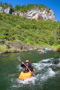
Kayaking the South Fork Salmon River Photo: Scott Harding
The Salmon River is recognized as one of the finest whitewater river systems in the world. With clean water, no dams, and almost 100 miles of runnable whitewater varying in difficulty from Class II to V, there is something for just about every river runner.
Whitewater boating season begins when late fall rains raise river levels and continues into spring or early summer as the accumulated winter snowpack melts off the surrounding Salmon Mountains. Flows can fluctuate rapidly with rainfall and snowmelt.
While most sections of Salmon River system are easily accessed by road, paddlers looking for remote adventures will also find trail accessible wilderness runs.
The Salmon River, its North Fork, South Fork, and Wooley Creek are state and federally designated Wild and Scenic rivers.
Salmon River
The mainstem of the Salmon River is the most popular and infamous section of the river. You will never hear a local use the term, but paddlers sometimes refer to the river as the "Cal Salmon" to differentiate it from the better-known Salmon River in Idaho.
By starting in Forks of Salmon, paddlers can enjoy a four-mile run through Class II+ rapids to finish at Nordheimer Flat before the large rapids begin.
The Nordheimer Flat to Butler Creek section ("Nordheimer Run") contains 25 rapids, several of which are Class IV-V. The Butler Creek to Brannons Bar section ("Butler Run") is Class III-IV with one rapid that cannot be portaged (Gaping Maw, IV). Both of these sections have reasonable river access only at the common put-in and take-out points. The lowermost four miles of the river (Brannon Bar to the Klamath River) offers spectacular Class II+ whitewater and multiple access points.
 Several whitewater
rafting companies offer trips on the Salmon River and a world-renowned kayak
school is located in Forks of Salmon.
North Fork Salmon River
The smaller of the Salmon River’s two forks, the North Fork flows from the Marble Mountain Wilderness Area to Forks of Salmon through an intimate canyon of alternating rock types that create an abundance of diverse whitewater rapids.
Because of its smaller size, the North Fork is often a great choice when the mainstem Salmon River is at higher flows.
The Idlewild-Sawyers Bar section is an action-packed Class III+/IV- run through a narrow gorge. Paddlers can extend this run by starting upstream of Idlewild at Mule Bridge if flows permit. Intrepid paddlers can hike into the Marble Mountain Wilderness Area to start even higher with lots of Class II-III rapids. Please see the note below on river access issues in Sawyers Bar and be sure to use the public take-out in town rather than trespass on private property.
The scenic four-mile section beginning in Sawyers Bar is one of the best sections of Class II+/III- whitewater in the region and is never crowded. Just be sure to take out at the Gallia river access if you aren’t planning to continue into the more difficult canyon section below (the Gallia river access is just upriver of the 10-mile marker on Sawyers Bar Road and is marked with a River Access sign).
Advanced paddlers prepared for continuous Class III-V rapids will enjoy the 6.8-mile canyon run from the Gallia river access to Saw Pit Flat river access (near the four-mile marker on Sawyers Bar Road). After a brief warm-up, the pace is fast as the river flows alternately through granite boulder gardens and ledge drops before easing slightly in the last mile.
Beware: two miles downstream from Saw Pit Flat river access, the river goes beneath a swinging bridge then quickly enters the otherwise inaccessible Class V Indian Point Gorge. Do not attempt to paddle this section unless you know what you are getting into; it is nearly impossible to enter and exit this gorge except by river and it contains the greatest single concentration of large rapids in the Salmon River system, including boulder-choked Indian Point Falls, a convoluted and dangerous Class V rapid (portage on river left).
Access Issues on the North Fork Salmon River
Sawyers Bar
The only public river access in Sawyers Bar is via the short trail to a sandy beach that is almost directly across the road from the historic Catholic church on the downriver end of town--look for a River Access sign in a tree along Sawyers Bar Road where the trail heads down to the river. All other access points in town are on private property. In addition to being the only public river access in Sawyers Bar, this is also the nicest access point and has a parking area next to the historic church and a beautiful sandy beach on the river. This is the typical take-out for the Idlewild run but it can also be used as a put-in for the easier section of the North Fork below Sawyers Bar or to extend the North Fork canyon run by adding a few easy miles to the start. Check out a map and photos of the river access point and download the Sawyers Bar River Access Map [PDF file].
Little North Fork
Please note that most guidebooks direct paddlers to tresspass on private property at the Little North Fork to put in for the North Fork canyon run. Please avoid trespassing and use the public put-in located one mile downriver at the dirt road just upstream from the 10 mile marker on Sawyers Bar Road (look for the "River Access" sign). There is no loss of whitewater. You can also put in upriver near the 12 mile marker at Kelly Bar and gain a nice, scenic section with one easy Class III- rapid just above the Little North Fork confluence.
South Fork Salmon River
Slightly longer and larger than the North Fork, the South Fork originates at a perennial snowfield in the high Trinity Alps and often has a tinge of glacial green color during spring runoff. Although it is possible to paddle upper reaches above Cecilville, most paddlers focus on two runs downstream.
One of the more challenging and scenic runs in the watershed, the South Fork Gorge has technical and powerful class IV-V rapids all the way from the LeGaurde river access put-in to the take-out at Matthews Creek. It can be run at a wide range of flows. Some paddlers choose to continue past Matthews Creek to the Methodist Creek river access, adding 3-½ miles with one Class IV gorge.
Perhaps the most popular run on either of the Salmon River’s two forks, the Methodist run from Methodist Creek river access to Forks of Salmon offers six miles of Class III whitewater suitable for rafts and kayaks. The run is technical at lower flows and full of large waves and playspots at high flows.
Tributaries
Smaller tributaries in the watershed are less frequently paddled and include Wooley Creek, Bridge Creek, Steinacher Creek, Crapo Creek, East Fork South Fork, Little North Fork, and Knownothing Creek (be aware of multiple log jams in the lowermost mile of this stream).
Choosing a Run
Be sure you are putting on an appropriate section of river for your group's skill level. Due to the rugged terrain, powerful currents, and remote location, any emergency evacuation is a challenging prospect and help may be unavailable. There is not a local swiftwater rescue crew. All paddlers should be prepared to handle rescue themselves.
There
is no definitive guidebook to the whitewater of the Salmon River
watershed. The most complete information is found in The New School Guide to Northern California Whitewater. Next best is A
Guide to the Best Whitewater in the State of California, although it is outdated, incomplete, and sometimes quite erroneous. Online resources are also fairly incomplete but include American Whitewater, Dreamflows, and A Wet State.
Be sure to check out the Salmon River Watershed In-Stream Hazards Map for known hazards that may affect whitewater paddlers. This map is a useful reference, however, do not assume that all hazards are on this map.
Flow Information
Realtime river flow information is shown below and is also available on Dreamflows or from USGS. Water levels can change very quickly, especially during winter storms and spring runoff.
Paddling season typically begins in November or December when cold rains bring the rivers up and continues through spring runoff which ends in late June or early July in "normal" years. On low snowpack years, runoff can end as early as May. Mid-summer is better suited to swimming than paddling as water levels become quite low. Two of the easier sections of the Salmon River are suited for summertime tubing as well, particularly between Forks of Salmon and Nordheimer and also from Brannon Bar to the Klamath River confluence.
Realtime Salmon River Flows and Estimates
| River / Fork | Flow (cfs) | Change | Time & Date |
|---|---|---|---|
| Salmon River at Somes Bar+ | cfs/hour | ||
| Salmon River at Forks of Salmon* | cfs/hour | ||
| South Fork at Forks of Salmon+* | cfs/hour | ||
| North Fork at Forks of Salmon+* | cfs/hour | ||
| Wooley Creek at Salmon River* | cfs/hour | ||
| Little North Fork at Salmon River* | cfs/hour |
* = estimated flow (accuracy uncertain, do not rely upon for running whitewater), + = flow courtesy of Dreamflows
Wilderness Hiking, Packing, & Camping
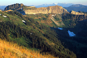 Marble Mountain & the Trinity Alps in the distance
Photo: Scott Harding
Marble Mountain & the Trinity Alps in the distance
Photo: Scott HardingThe Salmon River is home to portions of three federally-designated wilderness areas and a stunning section of the Pacific Crest Trail. The Bigfoot Trail, a 360-mile long route through the Klamath Mountains is under development and passes through the Salmon River watershed. Excellent hiking and horse packing opportunities can be found year-round here, although only mid-summer to mid-fall allows snow-free access to the high country trails. Horse packers are required to bring in feed in the early season and some areas are closed to grazing at all times. Please consult the Klamath National Forest wilderness rules and regulations and practice Leave No Trace principles. A California Campfire Permit is required for all campfires and stoves.
Trinity Alps Wilderness Area
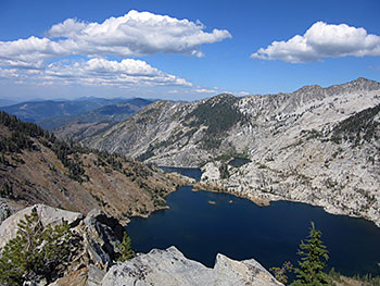 Caribou Lakes Basin in the Salmon River's Trinity Alps
Photo: Scott Harding
Caribou Lakes Basin in the Salmon River's Trinity Alps
Photo: Scott HardingThe Trinity Alps is an expansive mid- to high-elevation wilderness area covering 2,090 km² (517,000 acres) centered on the granitic mountains dividing the Trinity, Scott, and Salmon River watersheds. More than 1,280 kilometers (800 miles) of backcountry trails crisscross the Trinities, many of them leading to one of more than 100 lakes. Access points on the Salmon River side include Big Flat and the South Fork Salmon trailheads out of Cecilville and High Point trailhead near Forks of Salmon. Not all secondary trails are regularly maintained so be sure to check on current status before departing on your trip.
Our recommended guidebook is Hiking
California's Trinity Alps, although this book oddly leaves out the entire western half of the wilderness area and therefore, nearly all of the Salmon River watershed's portion of the wilderness.
We sell wilderness maps in
our online store and at our watershed center in Sawyers Bar.
Russian Wilderness Area
The small but rugged Russian Wilderness covers 49km² (12,000 acres) on the divide between the Salmon and Scott Rivers. The Russian Wilderness is globally recognized for having among the highest species diversity of conifers on the planet. Eighteen conifer species can be found here. As if that's not enough, the Pacific Crest Trail traverses the wilderness and there are 22 high country lakes set beneath towering granite peaks. South Russian Creek has been deemed eligible for inclusion in the National Wild & Scenic River Sytem and is awaiting formal designation. Access is at Etna Summit, Taylor Lake trailhead, South Russian Creek trailhead, Cecilville Summit, and from Forest Road 39.
Our favorite guidebook is Marble
Mountain Wilderness with Best
Hikes of the Marble Mountain and Russian Wilderness Areas
being
a runner up. Both of these books cover both wilderness areas. We sell wilderness
maps in our online store and at our watershed center in Sawyers Bar.
Marble Mountain Wilderness Area
The Marble Mountain Wilderness Area is a biological and geological melting pot set upon the junction of the Salmon River, Scott River, and Klamath River watersheds. The wilderness area has hundreds of miles of trail and over 90 mountain lakes within its 978 km² (241,744 acres). The Salmon River's primary year-round hiking trail, the Wooley Creek Trail, is located in the southwestern portion of the wilderness. Because of its low elevation, this trail is usually snow-free through winter (except after big storms). Other access points are on the Camp Three Road, Sawyers Bar Road at Garden Gulch (poorly maintained), the Little North Fork Road (poorly maintained), Cherry Creek Road, the Mule Bridge trailhead above Idlewild Campground, and at Etna Summit. There is a stunning assortment of wilderness whitewater paddling opportunities here for intrepid hike-in paddlers, and packrafts are well-suited to these wilderness boating opportunities.
Our favorite guidebook is Marble
Mountain Wilderness.
Next best is Best
Hikes of the Marble Mountain and Russian Wilderness Areas
.
Both of these books cover the Marbles and the Russians. We
sell wilderness maps in
our online store and at our watershed center in Sawyers Bar.
Camping
There are 12 developed US Forest Service campgrounds in the Salmon River watershed. Ranging from small, no-fee campgrounds to larger fee-based campgrounds (some with group campsites and drinking water but none with showers), there are almost always available sites. The greatest number of campers visit on Memorial Day and Labor Day weekends; some campgrounds fill to capacity at these times. Several campgrounds and trailheads offer access for those with disabities.
Leave No Trace Principles
- Plan Ahead and Prepare
- Travel and Camp on Durable Surfaces
- Dispose of Waste Properly
- Leave What You Find
- Minimize Campfire Impacts
- Respect Wildlife
- Be Considerate of Other Visitors
see Leave No Trace for more info
At-large camping is permitted on much of the Klamath National Forest. Please consult the Klamath National Forest for complete rules and regulations and practice Leave No Trace principles.
Campfire Permit
Any campfire, cooking grill, or cooking stove operation requires a valid California Campfire Permit. These can be obtained for free online or at any Forest Service, California Department of Forestry and Fire Protection Office, or Bureau of Land Management office.
Please be especially careful with fire. Our watershed has a high fire danger for most of the summer and early fall and has recently experienced several large wildfires.
Fishing & Hunting
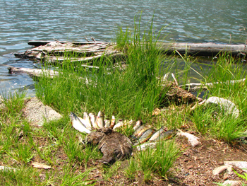
Marble Mountain Bounty Photo: Hunter McBroom
Due to its remote location and tighter-than-average regulations, the Salmon River receives only modest fishing and hunting use. All fishing and hunting requires a valid license and tags and is regulated by state law and enforced by California Department of Fish and Wildlife. Regulations change periodically so be sure you have a current copy of state regulations for the area.
Fishing
Salmon Fishing
The Salmon River and its tributaries are always closed to any salmon fishing. This is to protect the wild salmon fishery in the watershed.
Steelhead Fishing
How to Release Fish Unharmed
- Land your fish as carefully and quickly as possible.
- Try to avoid removing the fish from the water. Underwater unhooking and release is preferred.
- Do not squeeze the fish, or touch its eyes or gills.
- Remove only those hooks that you can see and remove easily, otherwise clip the line near the mouth on deep hooked fish.
- Use artificial lures (no bait) to minimize deep hooking. Barbless hooks or hooks with flattened barbs make unhooking easier and less stressful on the fish and are required on the Salmon River.
Catch and release fishing for steelhead is allowed each year between November 1 and February 28 on certain sections of river using only barbless hooks (see map [PDF file]). No steelhead or trout may be kept unless they are hatchery fish with clipped adipose fins; these are very uncommon in the Salmon River.
Dates may change and additional rules re sometimes in effect so be sure to check CDFW's Klamath River Basin Fishing Regulations that cover the Salmon River watershed.
Segments of the Salmon River & its Forks open to steelhead fishing:
- Salmon River mainstem (Forks of Salmon downstream to mouth)
- North Fork below Eddy Gulch bridge (in Sawyers Bar)
- South Fork below the East Fork confluence (near Cecilville)
Please handle fish as little as possible and only with wet hands. Better yet, there are gloves available which don't damage the live skin of fish. A good technique for releasing untouched fish is to grasp hook shank upside down and shake lightly.
Trout Fishing
Certain tributaries of the Salmon River and its Forks are open to resident rainbow trout fishing. Please consult the fishing map [PDF file] to identify these stream reaches.
Many of the high country lakes in the Marble Mountain, Russian, and Trinity Alps Wilderness Areas are stocked with brook and rainbow trout and are open to fishing.
Hunting
Hunting is regulated and enforced by the California Department of Fish and Wildlife. Licenses and tags are required. Most hunting on the Salmon River is for big game although some upland game bird and small game hunting is also done.
Most of the Salmon River watershed is public land administered by the Klamath National Forest. Please be sure you are not shooting in the vicinity of private residences, all of which are located immediately adjacent to public lands in the Salmon River watershed.
Snowsports
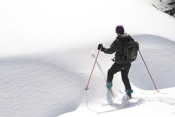 Skiing to Taylor Lake, Russian Wilderness Area
Photo: Scott Harding
Skiing to Taylor Lake, Russian Wilderness Area
Photo: Scott HardingAlthough there are no developed snowsport facilities tn the Salmon River watershed, there are great backcountry skiing, snowboard, and snowshoeing opportunities. The higher elevations of the watershed receive 2-8 meters (6-20 feet) of snow in a typical winter and snowpack usually begins at 1,350 meters (4,500 feet) elevation.
Access
Experienced winter recreationalists can access the high country of all three wilderness areas, however, most winter recreation takes place in the vicinity of Etna Summit and Carter Meadow Summit where plowed county roads offer relatively easy day access to trails and slopes. Be aware that roads are not plowed at night and only sometimes on weekends. Carry chains or other traction devices, extra food, water, and blankets in case you get stuck.
The Carter Meadows area near the Carter Meadow Summit and the Taylor Lake Road near the Etna Summit offer ungroomed cross country ski routes as well as access to moderate and steep backcountry terrain in the Trinity Alps, Russian, and Marble Mountain wilderness areas. Intrepid snow adventurers can have the entire interior of any of the three local wilderness areas to themselves if they are willing to venture just a few miles beyond the access points.
Backcountry Snow Safety
Please be knowledgeable and aware of avalanche dangers and safety before venturing onto backcountry slopes and carry appropriate equipment for traveling in avalanche-prone areas. As would be expected, some areas are very avalanche-prone.
Cycling
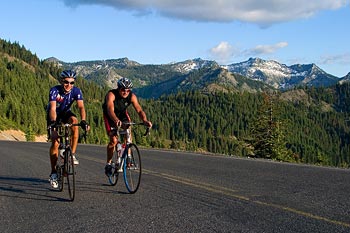 Cycling over Etna Summit on Sawyers Bar Road
Photo: Scott Harding
Cycling over Etna Summit on Sawyers Bar Road
Photo: Scott HardingThe Salmon River is an excellent and largely undiscovered location for backcountry bicycling.
Mountain Biking
Although almost all maintained single track trails are located in designated wilderness areas and are legally off-limits to cycling, there are hundreds of miles of dirt roads open to mountain biking. Very few non-wilderness trails that are open to mountain bikes have have been adequately maintained, and, as such, there is very little trail riding that is currently accessible. Hopefully this will change with improved front country trail management; however the trend is toward loss of most trails due to lack of maintenance.
Featured Ride: Picayune Road (#39)
The out-and-back dirt road ride from Forks of Salmon to the Blue Ridge Lookout Tower on the Picayune Road (#39) offers mountain bikers and gravel bikers a wonderful out-and-back ride with spectacular views. It's all uphill to the lookout with a total elevation gain of about 1,350 meters (4,500 feet). It is possible to descend from the lookout to Sawyers Bar or Cecilville as well. Other nice dirt road rides include the Yellow Jacket Road near Forks of Salmon, the Eddy Gulch Road near Sawyers Bar, and the Knownothing Creek Road on the South Fork. A gravel bike or cyclocross-style bike is well suited to the Salmon River's abundant dirt roads, including the Picayune ride. This ride is best in late spring, summer, and fall.
Road Biking
Quiet, winding mountain roads, scenic river and mountain views, and a mix of moderate and steep climbs make the Salmon River ideal for backcountry road biking and bikepacking. All three paved roads in the watershed (on the river's North Fork, South Fork, and mainstem) offer wonderful road biking opportunities in the form of out-and-back rides or a long loop ride. For touring cyclists, several roadside US Forest Service campgrounds provide nice overnight camping options. Local cyclists will tell you that the Salmon River area is better suited to road biking than mountain biking, and the paved roads are well-maintained with good chipseal surfacing.
Featured Ride: The Salmon River Century Loop
The Salmon River Century Loop is considered to be one of the most spectacular road rides in California, if not the entire country. Begin this classic but grueling ride in Forks of Salmon. Ride up the North Fork to Etna Summit, descend to Etna in the Scott Valley and continue south on Highway 3 to Callahan. Turn right onto Cecilville Road, climb up to Callahan Summit and finish with a cruisy descent back to Forks of Salmon via Cecilville after stopping at the Salmon River Saloon for a cool down. There is nearly 3,200 vertical meters (10,468 vertical feet) of climbing on this 165 km (102 mile) ride. Snow and abundant cinders on the road can be an issue in late fall to mid spring. June is the most popular month and often has the best weather but fall can be ideal too.
Etna is an alternate starting and ending point. Regardless of direction of travel, the Etna Summit climb (9-13% grade) is steeper than the Callahan Summit climb: choose whether you want a hard climb earlier or later in your ride when considering which direction to ride this loop. The steepest portion of the entire loop is near the final mile going up Sawyers Bar Road to Etna Summit on the Salmon River side and comes at the tail end of a four-mile long 8-11% grade (for those riding the loop clockwise). Forks of Salmon to Sawyers Bar is surprisingly rolly with 275 meters (900 feet) of rolling climbs in addition to the 265 meters (1,000 feet) of elevation difference between the two small towns. More information can be found at Siskiyou Velo.
Due to the remote nature of the area and near complete lack of services on this ride, cyclists should come fully prepared to support themselves. It is highly recommended to bring a filter bottle as potable water is not available except in a few locations but clean roadside streams are abundant. A satellite communicator device such as an inReach or SPOT can greatly expedite an emergency call if needed; phones are few and far between and there is no cell service anywhere on the Salmon River side of the mountain.
Watch for Traffic, Wildlife, and Rocks!
Although our roads are fairly quiet and you may not see many cars, always ride to the right and be prepared for traffic at all times. The curvy, blind nature of the roads often makes seeing oncoming traffic an impossibility. Cyclists here have had serious and even fatal accidents involving vehicles, bears, squirrels, and rocks.

Salmon River Restoration Council
PO Box 1089 | Sawyers Bar, CA | 96027
Salmon River (California)
530-462-4665
![]()