Salmon River Restoration Council
- Overview
- Projects in Progress
- Projects in Planning
- Completed Projects
- Program Contact
Overview
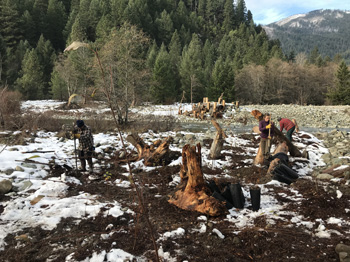 Kelly Bar Project included planting native trees and shrubs around the large woody structures.
 SRRC’s Habitat Restoration Program focuses on the resoration and enhancement of degraded fish habitat in the Salmon River, its two forks, and tributaries in order to benefit spring and fall Chinook salmon, coho salmon, winter and summer steelhead, lamprey and sturgeon.
SRRC has been engaged in habitat restoration efforts since 1992 and, with our partners, we have addressed many of the high priority fish passage barriers and treatable sediment sources in the watershed. Recognizing the critical need to work on larger, more complex in-stream habitat restoration projects, we created our Habitat Restoration Program in 2015 and are working on several projects and have others in planning stages.
A Critical Restoration Need
Although the Salmon River and its watershed are beautiful and appear relatively untouched by humans, nearly the entire river system has been substantially altered and the river’s fish habitat is significantly degraded. In particular, elevated summer water temperatures, reduced floodplain connectivity, diminished channel structure, coarsened riverbed material, degraded riparian condition, and barriers to fish passage are all major stressors to fish while they are in the Salmon River system. Degraded habitats include juvenile rearing habitat, overwintering habitat, and suitable spawning habitat. Spring Chinook and coho salmon currently face a high risk of extinction.
Floods, landslides, and wildfires affect the river system in various ways and are essential natural processes that help create, shape, and diversify fish habitat. Anadromous fish are specifically adapted to existence in river systems with great natural variability and have thrived in the Salmon River for thousands of years under these conditions.
However, human activities have greatly impacted the integrity and function of the river system, contributing to a dramatic alteration of fish habitat. Historic-era gold mining—most notably the extensive hydraulic mining and in-river dredging that occurred from the 1870’s to 1920’s—has greatly impacted Salmon River fisheries. This mining activity fundamentally changed the structure of the river channel, scouring it out in places while armoring and elevating it in others. Massive quantities of sediment, cobbles, and boulders were added to the river as banks and high bars were mined off. Side channels and floodplains were filled in or washed away, leaving behind a simple channel configuration with lower quality fish habitat. Shady, forested river banks were transformed to shadeless piles of mine tailings, contributing greatly to increased water temperatures. Other human-caused impacts include sedimentation from forest roads and related landslides, the depletion of large wood debris in streams, the creation of barriers to fish passage, and the contribution to an increase in wildfire impacts as an unintended consequence of fire suppression.
These human-caused impacts to the channel and floodplain are resistant to natural recovery processes and require active restoration efforts so that recovery can occur within a time frame that prevents further fish population declines and the possible extinction of Salmon River salmon. SRRC’s Habitat Restoration Program was developed specifically to address these critical needs by utilizing proven and well-designed fluvial process based restoration methods at key sites throughout the watershed.
Project Lifecycle
SRRC’s Habitat Restoration Program utilizes a proactive, science-driven approach to restoring fish habitat at prioritized sites throughout the watershed. Extensive data analysis and field-based studies are used to identify habitat restoration needs and opportunities and to prioritize potential project areas. Next, a rigorous conceptual design process develops professionally engineered site-specific restoration plans. Prior to implementation, we work closely with the Klamath National Forest to complete environmental review and permitting; nearly all opportunities for habitat restoration are located on public National Forest system lands. Finally, pending full approval and funding of the project, we utilize experienced environmental restoration contractors to implement the project according to the designs and plans. Follow up study and monitoring is then conducted to evaluate the performance of the project and to aid in the improvement of future projects.
This work ties into the Salmon River TMDL and Implementation Plan, the federal Southern Oregon/Northern California Coho Salmon Recovery Plan, and the state Recovery Strategy for California Coho Salmon.
Current Projects
Red Bank Habitat Enhancement Project
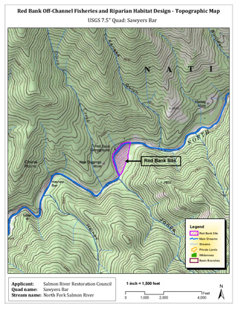
The Red Bank Habitat Enhancement Project will create and enhance coho habitat along a large alluvial floodplain/bar complex in the North Fork Salmon River. Click for more maps.
This project focuses on enhancing winter rearing habitat on critical reach of the North Fork Salmon River that is known to be used by coho salmon. A lack of winter rearing habitat, along with high summertime water temperatures, are identified by the SONCC Coho Recovery Plan as the greatest stressors for juvenile coho in the Salmon River. Fewer than 50 adult coho salmon are estimated to return to the Salmon River annually, down from historic numbers of a thousand or more.
The Red Bank reach of the North Fork, located about seven miles upriver from Forks of Salmon, is dominated by a large, mostly barren alluvial floodplain/bar complex that confines the main river channel firmly against the right bank. This complex is formed, in part, by deposits from the abundant historic hydraulic mining and dredging that took place upriver and at this site between the 1870s and late 1920s. It was significantly transformed by the 1964 flood event, re-routing the river from its previous course, resulting in a simplified channel structure and disconnected floodplain and side channels. What was once a reach of river with a wide floodplain, several side channels, and off-channel alcoves is now reduced to single fast-moving river channel at most flows. Side channels flow only for short durations at high water. These changes have reduced habitat diversity and complexity, and, specifically, the availability of lower velocity refuges for juvenile coho during high water events in winter.
The Red Bank Habitat Enhancement Project will actively restore a diverse channel structure and habitat throughout the Red Bank floodplain/bar complex by utilizing a combination of engineered wood structures (bank logs, root wads, apex jams, abutment jams, etc.), excavated backwater alcoves and off-channel pools, and brush baffles. This will create abundant low-velocity habitats in side channels away from the main river flow during winter flows and provide more consistent flows for existing side channels.
On-site evaluation, groundwater monitoring, and full engineering designs for the project have been completed. Implementation is anticipated to be completed in 2020, following completion of environmental review and permitting.
Hotelling Gulch Fish Passage & Stream Restoration Project
This project will restore a section natural stream channel, remove a fish barrier, and open Hotelling Gulch to anadromous fish passage. More information will be posted about this project shortly.
Detailed project info is available from the Klamath National Forest.
Download the Hotelling Gulch Fish Passage and Stream Restoration Project Environmental Assessment [PDF].
Projects in Planning
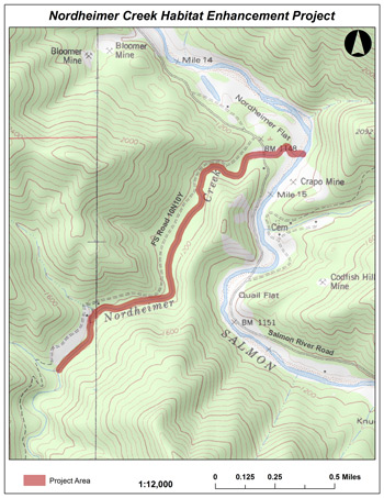
Nordheimer Creek Habitat Enhancement Project
Nordheimer Creek, a major tributary to the mainstem Salmon River, has abundant cool water and low gradient reaches, two essential habitat components for coho salmon. The stream, however, is underutilized by coho due to simplification and fragmentation of fish habitat that has resulted from past human activities in the watershed including hydraulic mining, extensive logging, and the removal of large wood from the stream channel. Additionally, changes to the natural fire regime have reduced current and future recruitment of large wood debris into the stream channel.
SRRC is in the early planning phase for a potential future fisheries habitat restoration project for lower Nordheimer Creek aimed at improving habitat conditions for coho as well as other species. In 2014, we completed an assessment of existing natural large wood debris structures and habitat complexity in Nordheimer Creek. This assessment indicated that there is a distinct lack of wood structures and habitat complexity that limits spawning and rearing for coho and other salmonids in the creek. In October 2017, SRRC installed groundwater monitoring wells near the mouth of the creek as part of a study that will be used to inform future engineering designs for the habitat restoration project.
This project will address specific high priority coho recovery actions that are identified in the the federal Southern Oregon/Northern California Coho Salmon Recovery Plan, and the state Recovery Strategy for California Coho Salmon. The project will provide short-term and long-term benefits to coho and other species by restoring large wood debris and riparian shading in a key cold-water tributary to the Salmon River.
Salmon River Floodplain Habitat Enhancement & Mine Tailing Remediation Project
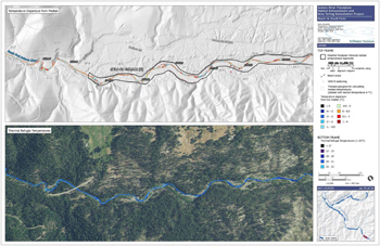
The Salmon River Floodplain Habitat Enhancement and Mine Tailing Remediation Project is a watershed-wide approach to strategically restoring stream temperatures, geomorphic functions, and aquatic habitat in the Salmon River with the goal of increasing long-term salmon and steelhead productivity and ensuring that the Salmon River remains a refuge for anadromous fish, even in a time of climatic change. Specific objectives include increasing the availability and quality of over-wintering, over-summering, and spawning habitat; improving riparian functions such as shade cover and hyporheic exchange between floodplain and channel; and protecting and enhancing summer thermal refugia.
This represents the most comprehensive habitat restoration effort yet undertaken in the watershed and will ultimately constitute an array of habitat restoration and enhancement projects over a sustained period of time. As such, the assessment and planning phase is comprehensive in scope and is a significant undertaking in itself. SRRC is currently working on this phase (Phase 1), the first of four for the entire project. The other three phases include the development of specific project designs within prioritized stream and river reaches, environmental review and permitting, and implementation of prioritized restoration and enhancement projects.
Using aerial imagery, remote sensing data (LiDAR and TIR), field research, and GIS analysis, the Phase 1 assessment analyzed 55 miles of river channel to identify reaches that possess three criteria:
- have the type of wide, predominantly alluvial channels and floodplains that historically provided the greatest floodplain habitat values,
- have been most impacted by historical mining and other disturbances, and
- provide the greatest opportunities for restoring floodplain habitat.
Eighteen reaches totaling 35 miles were identified as possessing all three criteria and were then individually characterized and mapped in high resolution detail for their geomorphic characteristics, summertime water temperature profiles, and flow inundation. Additionally, each reach has been ranked for restoration and enhancement potential.
Although specific restoration and enhancement actions will be developed in future phases of this project, potential actions may include:
- Protecting and expanding cold water refugia at summer baseflow within the mainstem channels and lower reaches of major tributaries to improve holding and summer rearing habitat conditions,
- Adding bankfull channel structures that create hydraulic complexity and pool depth, increase the amount and quality of low-velocity winter rearing habitat, and sort spawning gravel,
- Grading and revegetating floodplains to increase flow connectivity and hyporheic exchange between the winter baseflow channel, bankfull side channels, and high flow side channels,
- Adding structural complexity to side-channels to improve winter rearing habitat,
- Creating, enhancing, and connecting off-channel ponds and wetlands to improve winter rearing habitat, and
- Grading and revegetating mine-tailings on floodplains and adjacent terraces to increase riparian shading, reduce heating, and improve hyporheic exchange.
The highest priority recovery actions include those identified in the Salmon River TMDL and Implementation Plan, the Southern Oregon/Northern California Coho Salmon Recovery Plan, and the Recovery Strategy for California Coho Salmon, as well as other specific measures identified to be most effective at recovering the spring-run Chinook salmon populations within the Salmon River.
Windler Bar Habitat Enhancement Project
This project is in initial planning stages and will be located on the North Fork Salmon River about 1.5 miles downstream of the Little North Fork confluence. More info will be posted soon.
Completed Projects
Kelly Bar Habitat Enhancement Project
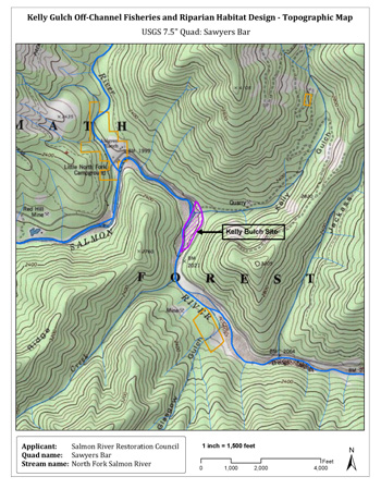
The Kelly Bar Habitat Enhancement Project will create and enhance off-channel coho habitat in the North Fork Salmon River. Click for more maps and design plan details.
This project creates and enhances off-channel habitat along a low-gradient reach of the North Fork Salmon River at Kelly Bar, about three miles downriver from the town of Sawyers Bar. This section of river is known to host rearing juvenile coho. Kelly Gulch, which enters the North Fork at the downstream end of the project site, is also used by juvenile coho, as are other nearby tributaries and refugial areas. The area has been identified as having High Intrinsic Potential in the SONCC Coho Recovery Plan SRRC's Fisheries Program has maintained fish passage from the river into Kelly Gulch for many years.
The project addresses five critical elements of long-term fisheries habitat restoration and maintenance of water quality on the Salmon River:
- access to slow water habitat where migrating smolts can take refuge from the strong hydraulics of the mainstem, increasing winter rearing habitat for juveniles
- access to over-summer rearing habitat through pool development
- providing low gradient, off-channel spawning habitat
- restoring riparian vegetation that provides shade and subsequent cooler water temperatures during warm summer/fall months and future large woody debris recruitment
- restoring large woody debris into barren side channels to provide increased cover and rearing habitat for adult and juvenile salmonids.
Due to a combination of factors, including the simplification and fragmentation of habitat, coho populations are declining in the Salmon River. In 2008, SRRC conducted an assessment that evaluated riparian conditions throughout the watershed. The assessment identified Kelly Bar as a high priority for restoration of natural riparian conditions and salmonid habitat.
Prior to completion of this project, the project area consisted of approximately 12 acres of mostly barren, large alluvial floodplain with several sparsely vegetated, discontinuous, remnant high-flow side channels and vegetated alluvial terraces. The high-flow side channels were dry throughout the summer and fall and were accessible by fish only during unusually high water wintertime flow events. The project enhanced these side channels to provide shelter for fish during high water events and to provide cold water thermal refugia in the summer months.
Habitat enhancements will include:
- improving connectivity to and enhancing existing side channels and creating alcoves on Kelly Bar and West Bar (directly across the river)
- enhancing two existing off-channel ponds on Kelly Bar.
Treatment included excavation of channels, alcoves, and ponds, constructing engineered log jams and small wood habitat features, planting a diverse species mix of native riparian vegetation, and reducing the density of non-native Himalayan blackberry thickets without using herbicides, and securing the project area from unauthorized cattle grazing with wire fencing.
This project was implemented in fall 2019. Monitoring and evaluation will be ongoing for several years.
Project Files
- Kelly Gulch Conceptual Design for Fisheries and Riparian Enhancement (75 Mb)

- Kelly Gulch Habitat Enhancement Final Basis of Design Report (60 Mb)

South Fork Tributary Habitat Enhancement Project
The large wood structures are in place in Knownothing and Methodist Creeks. More information will be posted about this project shortly.
Detailed project info is available from the Klamath National Forest.
Download the South Fork Tributary Habitat Enhancement Project Environmental Assessment [PDF].
Taylor Creek In-stream Barrier Removal & Bridge Project
The fish barrier has been removed and replaced with a new bridge. More information will be posted about this project shortly.
Riparian Restoration
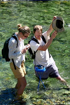
Analyzing riparian shading
The Salmon River Riparian Assessment was a multi-year project designed to bring the temperature-impaired waters of the Salmon River into compliance with water quality laws by reducing peak summer water temperatures. The assessment combined federal mandates, private funding sources, and the work of SRRC and our collaborators.
Importance of Riparian Vegetation
The reduction and compositional alteration of riparian vegetation along the river and its tributaries has led to increased solar exposure of the water and river bars. This, in turn, has caused an increase in water temperatures, primarily in the hot summer months. High water temperatures adversely affect the aquatic ecosystems and fishery of the Salmon River.
Additionally, loss of riparian vegetation makes stream banks more susceptible to erosion and ultimately leads to increased sediment delivery to the river.
Riparian vegetation may need to be reestablished after mining, road decommissioning, floods, fires, timber harvest, and livestock use.
Background
Water bodies in the Salmon River watershed are considered to be temperature-impaired and are therefore subject to regulation by the Clean Water Act. In compliance with the law, the California North Coast Regional Water Quality Board adopted the Salmon River TMDL and Implementation Plan in 2005. The goal of the plan is to reduce peak water temperatures by increasing riparian shading.
Due to a lack of federal resources to implement the plan, in 2006 the SRRC obtained private funding from the Bella Vista Foundation to complete an assessment of shade and revegetation potential for riparian areas throughout the Salmon River, and began to work towards eventual implementation of the TMDL. The plan requires an increase in vegetation cover and height within the riparian zone in order to reduce impaired water temperatures and improve fish habitat.
The Assessment Process
The SRRC and our collaborators (USFS, North Coast Regional Water Quality Control Board, Karuk Tribe, and others) completed a detailed assessment of riparian vegetation and shading potential for the entire Salmon River cooridor. At each site, the potential shading effect of vegetation was determined using a solar pathfinder. The SRRC’s GIS specialists created detailed maps of the sites.
Sites were prioritized based on a number of different factors, including vegetation deficency, aspect, access, and fish habitat potential. Based on the prioritization of sites, three river reaches were identified as having the greatest potential for restoration. Habitat Restoration projects will be planned, designed and implemented based on the results of this assessment.
As restoration projects are implemented, the river should begin to see increased shading and channel complexity, resulting in a reduction in peak water temperatures and an improvement in fish habitat.
Whites Gulch Dam Removal (2008)
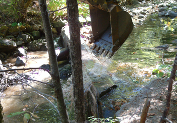
Excavater knocking the lower dam down.photo by Jim Villeponteaux
SRRC coordinated the removal of significant barriers to fish passage on Whites Gulch, a key tributary to the North Fork Salmon River. On October 1, 2008, the uppermost of two dams blocking fish passage was blasted by a CDFG crew. Two weeks later, the smaller dam downstream was removed with an excavator. Finally, in 2009, Siskiyou County removed a fish-blocking culvert and replaced it with a bridge, eliminating the final fish barrier on Whites Gulch. In all, Salmon River steelhead gained 1.5 miles of spawning habitat with the completion of this project. This project was a major milestone for the SRRC: not only did we successfully remove two dams, but we also completed our first full NEPA analysis for the project. Many thanks are due to the agency personnel who put in their time to make the project happen, as well as to the local landowners and equipment operators who did much of the groundwork. Check out our video of the upper dam blasting.
Program Contact
Melissa Van Scoyoc
Habitat Restoration Program Manager
Salmon River Restoration Council
PO Box 1089
25631 Sawyers Bar Road (shipping only)
Sawyers Bar, CA 96027
phone: 530-462-4665
fax: 530-462-4664

Salmon River Restoration Council
PO Box 1089 | Sawyers Bar, CA | 96027
Salmon River (California)
530-462-4665
![]()
