- Overview
- Barrier Removal
- Riparian Restoration
- Creek Mouth Enhancement
- Road Stewardship
- Program Coordinator
Overview
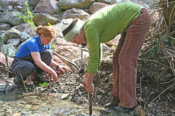
Riparian planting project
The SRRC has been restoring riparian areas in the Salmon River watershed since 1992.
Our riparian restoration projects include a long term riparian assessment and planting project to increase stream shading, creek mouth enhancement, revegetation after fish barrier removal, bank stabilization, and tailing pile restoration.
Riparian vegetation in the Salmon River watershed was substantially reduced during the gold mining era from 1851 to the early 1900's. Since that time, road-building, logging, additional mining, and erosional processes exacerbated by these activities have further reduced and altered riparian vegetation.
Importance of Riparian Vegetation
The reduction and compositional alteration of riparian vegetation along the river and its tributaries has led to increased solar exposure of the water and river bars. This, in turn, has caused an increase in water temperatures, primarily in the hot summer months. High water temperatures adversely affect the aquatic ecosystems and fishery of the Salmon River.
Additionally, loss of riparian vegetation makes stream banks more susceptible to erosion and ultimately leads to increased sediment delivery to the river.
Riparian vegetation may need to be reestablished after mining, road decommissioning, floods, fires, timber harvest, and livestock use.
Fish Barriers
Fish barriers occur naturally, but with our need to drive on roads to get around, man-made barriers such as culverts are common. Many of the once thriving fisheries streams in the west are being choked out due to huge inputs of sediment. The SRRC, in cooperation with local landowners, tribes, agencies, private specialists, and others has developed a multifaceted approach to understand and help manage the roads of the Salmon River.
Whites Gulch Dam Removal
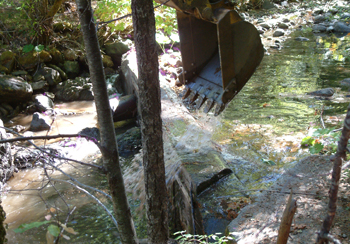
Excavater knocking the lower dam down.photo by Jim Villeponteaux
On October 1st 2008, the upper dam was blasted by a CDFG crew, and the lower dam was removed with an excavator 2 weeks later. In 2009 Siskiyou County removed a cluvert and replaced it with a bridge, eliminating the final barrier on Whites Gulch. Salmon River steelhead gained 1.5 miles of spawning habitat with the completion of this project. The completion of this project was a major milestone for the SRRC. Not only did we successfully remove two dams, but in order to do so, we had to complete our first full NEPA analysis for the project. Many thanks are due to the agency personnel who put in their time to make the project happen, as well as to the local landowners and equipment operators who did much of the groundwork. Click to view Video of Upper Dam Blasting.
Hotelling Gulch
The last County road barrier is at Hotelling Gulch up the South Fork. It has a complex channel alignment, and has required a number of feasibility and hydrologic studies to prepare for project design, which is scheduled to happen in 2014-15.
Riparian Restoration
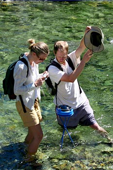
Analyzing riparian shading
The Salmon River Riparian Assessment and Restoration is a multi-year project designed to bring the temperature-impaired waters of the Salmon River into compliance with water quality laws by reducing peak summer water temperatures. The assessment combines federal mandates, private funding sources, and the work of SRRC and our collaborators.
Background
Water bodies in the Salmon River watershed are considered to be temperature-impaired and are therefore subject to regulation by the Clean Water Act. In compliance with the law, the California North Coast Regional Water Quality Board adopted the Salmon River TMDL and Implementation Plan in 2005. The goal of the plan is to reduce peak water temperatures by increasing riparian shading.
Due to a lack of federal resources to implement the plan, the SRRC obtained private funding from the Bella Vista Foundation and began work on implementing the plan in 2006. The plan requires an increase in vegetation cover and height within the riparian zone in order to reduce impaired water temperatures and improve fish habitat.
The Assessment Process
The SRRC and our collaborators (USFS, North Coast Regional Water Quality Control Board, Karuk Tribe, and others) completed a detailed assessment of riparian vegetation and shading potential for the entire Salmon River cooridor. At each site, the potential shading effect of vegetation was determined using a solar pathfinder. The SRRC’s GIS specialists created detailed maps of the sites.
Sites were prioritized based on a number of different factors, including vegetation deficency, aspect, access, and fish habitat potential. Based on the prioritization of sites, three river reaches were identified as having the greatest potential for restoration. Habitat Restoration projects will be planned, designed and implemented based on the results of this assessment.
As restoration projects are implemented, the river should begin to see increased shading and channel complexity, resulting in a reduction in peak water temperatures and an improvement in fish habitat.
Creek Mouth Enhancement
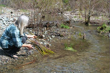
Riparian planting at Kelly Gulch
Our creek mouth enhancement projects aim to improve fish passage, side channel rearing areas, and refugia habitats by removing the temporary flow barriers often found at the confluence of creeks and the main river forks.
We have been engaged in ongoing work at the mouth of Kelly Gulch (a North Fork tributary) and other key areas in the watershed for several years. Volunteers strategically move rock and wood blockages by hand so that cold creek water is better routed into the pools at the creek mouth. Kelly Gulch's connectivity to the river has been gradually reestablished and a side channel rearing area has been opened up. In addition, we have been replanting riparian vegetation to provide shade and fish habitat.
Importance of Creek Mouth Enhancement
Recent research has revealed the critical importance of thermal refugia found at creek mouths during the summer months when river temperatures sometimes exceed the lethal levels for salmonids. Cold creek water fed into the river often collects at the creek mouth, providing a “pool” or thermal refugia of colder water that salmonids and other fish congregate in to avoid the stresses of warm river water. Summertime population densities in these thermal refugia is often much greater than that of any other part of the river.
Road Stewardship
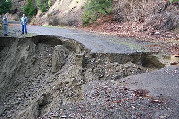
Sediment source on Little North Fork Road, 2006
Roads and road-related landslides contribute large quantities of sediment to the river system, especially during storm events. This sediment pollution can impair aquatic habitat and suffocate gestating fish eggs (redds).
The SRRC is committed to reducing and mitigating the delivery of sediment to streams and the river from both public and private roads.
National Forest Roads
National Forest road networks are considered by many to be the most damaging component of federal forest land management. Roads and road-related landslides generate the greatest amount of sediment pollution per acre of all types of watershed disturbances. They can alter hydrology, habitat connectivity, and the routing of wood debris and sediment. These combined effects have the potential to disturb aquatic environments critical to anadromous fish and other aquatic life.
The necessity to evaluate and implement measures to reduce
road-related impacts to watersheds is greater than
ever in light of decreasing road maintenance funds
allocated to the Forest Service by Congress.
The Klamath National Forest (KNF) has recognized the
need to reduce mileage of National Forest system roads.
To assist in this process, the SRRC completed the Salmon
River Sediment Source Assessment in 2001. This assessment identified
and measured all sources of sediment that have potential to deliver to streams
in the Salmon River watershed. The assessment has been used to update
the KNF’s Forest Transportation Map, create an
erosion hazard assessment for all roads in the watershed,
and assist in planning for road-related restoration in
the watershed.
Using the information provided by our assessment, the Klamath National Forest has completed 55 miles of storm proofing and 47 miles of decommissioning in the Upper and Lower South Fork road systems.
Private Roads
As part of an ongoing program, we sponsor community road stewardship workdays and workshops that encourage community members to care for the roads that they use. We completed a sediment source inventory of all roads in the watershed in 2001. This inventory has been used to prioritize sediment reduction efforts.
We are currently working with private landowners to assess and engineer improvements to their roads. The SRRC is funded to help engineer redesign projects that improve road stability and decrease erosion.
Program Coordinators
Karuna Greenberg, Primary Coordinator,Tom Hotaling, Creek Mouth Enhancement Coordinator,
Salmon River Restoration Council
PO Box 1089
25631 Sawyers Bar Road (shipping only)
Sawyers Bar, CA 96027
phone: 530-462-4665
fax: 530-462-4664

Salmon River Restoration Council
PO Box 1089 | Sawyers Bar, CA | 96027
phone: 530-462-4665
fax: 530-462-4664

Content is licensed under a Creative Commons Attribution-Noncommercial-Share Alike License
Site design by Scott Harding
